vtiger 6.1.0 Released
After several months of development the latest version of the most popular open source CRM, vtiger CRM is released today.
vtiger 6.1.0 provides new features, over 150 bug fixes and support for newer versions of PHP and MySQL, as well as the new all Extension Store & vtiger Marketplace where our own Geographic Information System extension, GeoTools, was the first to be approved and published.
Release notes for vtiger are here.
Downloads are here.
As always, the UK’s most experienced vtiger partner Libertus Solutions is available for support and assistance with any vtiger implementation.
GeoTools re-visited
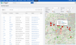
 Remember our first release of GeoTools? Libertus Solutions are delighted to announce the release of a completely re-written GIS (Geographical Information System) extension module for the soon-to-be-released vtiger 6.1.0.
This new version of GeoTools integrates services from OpenStreetMap with whatever business data is configured and available in your CRM application.
One of the big changes in the forthcoming 6.1.0 release of vtiger is a brand new integrated Extension Store feature that makes it simple for users to install and manage new extension modules for their vtiger installation:
- 1 Click install of commercial or free applications
- Confidence that apps are verified by vtiger before publication
- Contact information of publisher is immediately available
- See and contribute Ratings and Reviews of extensions
GeoTools is the first new extension module to be approved and published in vtiger’s new Marketplace and offers a host of new features that take full advantage of the new MVC architecture of vtiger 6.
- Use existing search filters and geographic parameters simultaneously in search results
- Manually update the location coordinates of records when they have not been Geocoded correctly by drag & drop
- Drag & drop the radius centre to re-calculate distance searches instantly
- Automatically detect the users actual location for an instant “any Leads nearby?” type enquiry
- Arbitrary manual address entry for on-the-fly geocoding
- Ability to add records directly to the Geocoding database cache using drag & drop
The techy bit
This version of GeoTools has been totally re-written from the ground up. We fixed a few bad design decisions that kind of “just happened” in the first version and have re-architected the internal Geocoding and Tile service APIs so these are now vendor agnostic. In the first GeoTools release we used the Google Maps API for both Tile and Geocoding services but these are now subject to terms & conditions which are probably not appropriate for the majority of businesses that would wish to use GeoTools. Consequently, this release now uses services from OpenStreetMap but other services from commercial vendors could just as easily be supported too; such as Google or MapQuest or MapBox.
We used the amazing Leaflet JS library to handle the majority of the mapping user interface. It’s a pleasure to use, well documented and is highly featured.
GeoTools is Open Source Software. We decided however to sell the extension via vtiger’s Marketplace for a nominal fee as we have spent considerable effort developing this product and believe it represents great value for money. Installation from the vtiger marketplace is a 1-click affair and we will provide support to paying customers. The GeoTools code will be available shortly on the vtiger forge but users will be on their own in terms of installation and support.
There isn’t a straightforward upgrade path between the version of GeoTools for vtiger 5.4.0 and this release unfortunately, although it should be possible to do for customers who have a large amount of data they’d rather not have to re-geocode. If you are interested in migrating please contact Libertus Solutions directly.
There will be a video showing GeoTools for vtiger 6.1.0 coming soon 🙂
UPDATE: There is now a demo system available here: http://geotools.libertus.co.uk. Login with a username and password of GeoTools. (This demo database is dropped and restored every 4 hours)
GeoTools: Geolocation services for vtiger CRM
As many of you know already, our company Libertus Solutions does quite a lot of work with the open source CRM called vtiger. It’s a very competent and accomplished product made even more so by its well thought out extension capabilities.
In this post I’m really pleased to announce our first open source vtlib module for vtiger called GeoTools.
It was derived from another project on the vtiger forge called Maps, which we have taken and extended in true open source style. Standing on the shoulders of giants, and all that…
GeoTools introduces Geolocation features to vtiger in a standard vtlib module package. It adds the ability to perform distance-based searches on your data.
GeoTools uses the Google Maps API to gather positional data, that’s latitude and longitude coordinates, for the entity records that have been configured in the GeoTools Settings area. Once we have acquired this positional data we can then perform location-based calculations to display the results on an embedded Google Map, and as a list view of entity records.
Anyway enough of the words already! Here’s a video:
As soon as the forge site is up I’ll update this and provide links to the code.
Update: Here we are: This will be a moving target for some time yet – it’s still rather “beta” grade code…


